A Geographer’s Perspective on the Existence of a Topographic Signature of Life
by Ryan Erickson
“Alice had begun to think that very few things indeed were really impossible.”
― Lewis Carroll, Alice's Adventures in Wonderland
Whenever I introduce my research to people, I am often asked “did you say geology or geography?” While it’s true that geographic research can involve the processes leading to the formation, composition and analysis of rocks, I can assure you, the two are distinct fields of study. Where the geologist specializes in paleontology, chemistry, and physics to decode processes that happen over millions of years, a geographer might use this to uncover the earthly relationship between bedrock compositions and stream flow, identifying potential areas of flooding for a nearby community. Perhaps as is true of the name, these are often done by examining historical effects of streams on the surrounding area. Simply put, we geographers are known as “Earth Writers” (Springer 2017), scribing the history of the human relationship on a 4.5-billion-year-old rock which we call home.
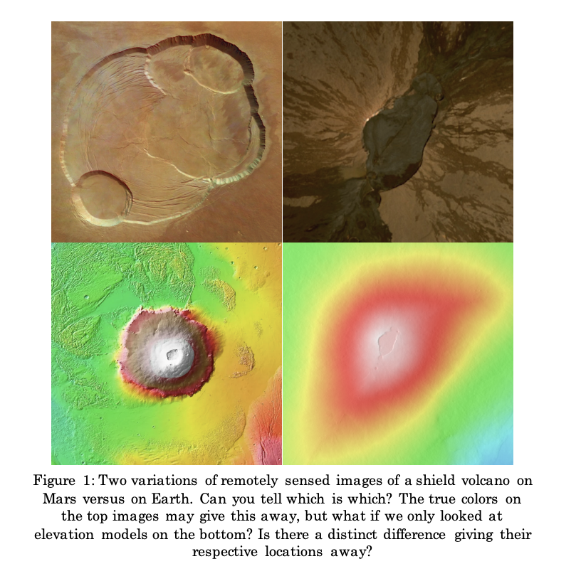
Given a more simple, modern perspective, geologic and geographic theory stem from two completely different questions: respectively, “what is that?” and “where is that?” Thanks to geologists, geographers typically have access to research regarding how an Earthly process occurs. If these are similar over time, yet have slightly different outcomes, then incorporating “where” can often reveal “when” and “why” something changes across space. Since the advent of satellite technology, GIS (geographic information system) has been dedicated to the storage, display, and analysis of large spatial-temporal datasets. In addition, theoretical frameworks, like Digital Elevation Models (DEMs), which are 3D numerical representations of Earth's surface, created from terrain elevation data; and the Normalized Difference Vegetation Indices (NDVI), which are measures of how green and healthy vegetation is, have been mathematically deduced to allow geographers to pose unique perspectives on the evolution and history of Earth (Kogan et. al., 2015).
NC CASC is dedicated to using these methods to understand how humans have impacted the land around us to aid with resource management. As the methods and expertise of research personnel at NC CASC are based in ecological analyses, we wanted to offer a potential new outlook on a topographic signature of life. As a human species, we still know very little about how life came to be on Earth, save a few topics rooted in abiogenesis or space dust crashing into Earth’s early atmosphere. Be it fossils or micro-organisms matching on different coasts, life seems to leave unmistakable footprints across Earth’s biomes. The influence of organisms on landscapes, and/or of landscapes on organisms, has long been recognized (Gnann et al., 2025), so does this transcend planetary constraints or is it a product of them? As life evolves in complexity, the effects of biological interactions on the environment become larger and more noticeable.
Evolution proves life can adapt to different environments, but does life have a similar, unmistakable impact on the land around it? The answer doesn’t lie in a singular answer, despite such seemingly limited choices. A common challenge to scientifically answer this yes or no question lies in the accessibility and advancements in remote sensing. At its core, remote sensing is based solely on physical properties of light. Does such a method exist in which we can detect distinct topographic signatures of life in any picture? Throughout this past summer, I had the opportunity to represent NC CASC to collaborate extensively with peers and researchers from across institutions to address this.
Building a living document of ideas, datasets and methods, we hope to ultimately propose a new outlook on the existence of topographical signatures of life. Ultimately, satellite detections can vary widely based on scale, climate, and landforms. Our work focused on parsing which of these patterns are detectable, over what time and spatial scales, and with what available data. Given the theory that life is an entropic process which uses energy to dictate order on its surroundings (Schrödinger, 1944), the impossibility that we can see life’s footprint on the land around within acquired signals of energy from satellites becomes seemingly possible.

We identified a series of hypotheses that might link biological presence to measurable differences in topographic form or signal. Alongside these hypotheses, we developed a communal list of exploratory questions to identify knowledge gaps and promising research directions. The relationships between life, topography, and climate are highly context dependent, requiring numerous disciplines to properly explain why the processes in an area occur (Dahlman and Renwick, 2014). For example, vegetation may suppress erosion in some systems but enhance it in others. Rain, which entices growth, has large erosion impacts on bedrock over time while attributing to vegetative erosion or support of topographical features. Some of the most pressing questions we found included:
- At what spatial and temporal scales can we detect a topographic signature of life?
- How do erosion and vegetation interact across climate gradients, and can we disentangle their respective roles in shaping landforms?
- Can ephemeral topographic changes — like those triggered by disturbances — reveal short-term biotic influence on the landscape?
- Does the statistical geometry of landforms like dunes or meanders vary systematically with vegetation presence, structure, or type?
The availability of appropriate data (e.g., LiDAR, InSAR and other high-resolution sources) now varies widely due to improvements made to geographic informational databases. Fine spatial scales at which different processes operate are now made possible. In response, we began thinking about how to utilize this powerful technology in meaningful ways. While no universal model applies, we identified a range of useful approaches to identify numerous actionable studies:
- Integrating vegetation and soil data with topographic metrics to assess biotic control over erosion.
- Comparing landforms across ecotones or transition zones where biotic influence varies.
- Employing multi-scale analysis to match the spatial and temporal dynamics of biological and geomorphic processes.
The ability to discuss these approaches allowed me to better gauge the incredible potential GIS offers to the world. The talent found within geographic researchers today surmounts to a rather humble beginning rooted in a very simple law: “Everything is related to everything else, but near things are more related than distant things,” (Tobler, 1970). With access to numerous specializations and disciplines, this project showed me a quintessential piece of what it means to be a Geographer, a jack of all sciences and master of one subject: Earth. The result of such multi-disciplinary work often provides a unique outlook for subjects approaching topics from a singular academic origin e.g., physics, chemistry, biology, etc.
Combining these disciplines by way of geographic theory and improvements to informational systems gives a new meaning to ways in which we write Earth’s history. The topographic signature of life could be a new lens for understanding ecosystem functionality and dynamics across any space. If life presents unmistakable topographic signatures, then we may be able to further reduce the number of potential locations in this vast universe which may house life.
About the Author:
Ryan Erickson is a Geography Master’s student at the University of Colorado, Boulder. He just completed his defense on “Integrating Machine Learning and Geo-statistics for High-Resolution Surface Ozone Mapping: A Case Study in Arizona”. Some of his research interests include GIS modelling, biophysics, and urban health management. In his free time, Ryan is an avid reader, sports fan, and gaming enthusiast. When weather and time permits, you can find him walking his cat, snowboarding, hiking, or on a basketball court. Ryan was part of the 2025 CAST (Climate Adaptation Scientists of Tomorrow) program. Read more about it here.
References
- Carroll, Lewis. 1865. “Alice's Adventures in Wonderland”.
- Dahlman, Carl; Renwick, William. 2014. “Introduction to Geography: People, Places & Environment” 6th ed. Pearson: 978-0137504510.
- Gnann, Sebastian, Jane W. Baldwin, Mark O. Cuthbert, Tom Gleeson, Wolfgang Schwanghart, and Thorsten Wagener. 2025. “The Influence of Topography on the Global Terrestrial Water Cycle.” Reviews of Geophysics 63 (1): e2023RG000810.
- Kogan, Felix, Mitch Goldberg, Tom Schott, and Wei Guo. 2015. “Suomi NPP/VIIRS: Improving Drought Watch, Crop Loss Prediction, and Food Security.” International Journal of Remote Sensing 36 (21): 5373–83.
- Schrödinger, E. 1944. “What is Life? The Physical Aspect of the Living Cell.” Cambridge University Press.
- Springer, Simon. 2017. “Earth Writing.” GeoHumanities 3 (1): 1–19.
- Tobler, W. R. 1970. “A Computer Movie Simulating Urban Growth in the Detroit Region.” Economic Geography 46 (June): 234.
- Zahnle, K., L. Schaefer, and B. Fegley. 2010. “Earth’s Earliest Atmospheres.” Cold Spring Harbor Perspectives in Biology 2 (10): a004895–a004895. https://doi.org/10.1101/cshperspect.a004895.


