


Super El Nino: Projected Impacts for the North Central Region
Date
The earth undergoes a natural cycle of atmospheric patterns called ENSO, or the El Niño Southern Oscillation, a coupled ocean-atmosphere pattern in the tropical Pacific that has three phases: neutral, La Niña (cold), and El Niño (warm). Last month, the National Oceanic and Atmospheric Administration (NOAA) declared that we are entering an El Niño phase. Officially, an El Niño occurs when the equatorial Pacific experiences temperatures 0.5°C above average for several consecutive months. This occurs when warmer waters displace the colder Humboldt Current along the coast of Ecuador, Peru, and northern Chile. An El Niño occurs approximately every 2-7 years, and usually causes unusual winter weather across the United States. During an El Niño, the southern US will likely be colder with more storms, while the northeastern US may experience milder, drier weather.
However, NOAA projects that this year’s El Niño will be stronger than recent ENSO events – a “super El Niño” – because temperatures in the equatorial Pacific have been greater than 2°C above average for several months. This does not necessarily mean that the effects of the El Niño will be stronger, but rather that El Niño effects are more likely to be felt across the affected region.
For the North Central region, an El Niño will have varying effects.
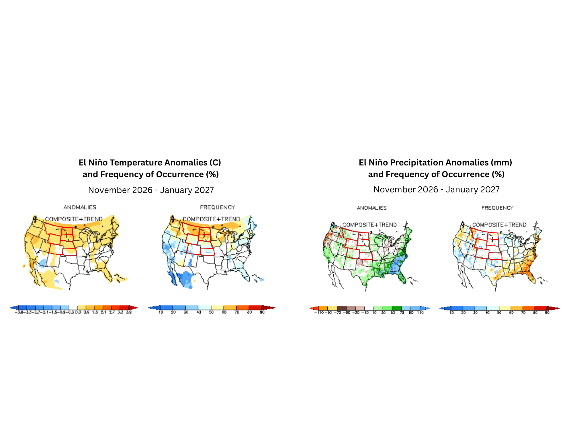
Images: El Niño Temperature (left) and Precipitation (right) Anomalies and Frequency of Occurrence: Composite and Trends for November 2026 - January 2027. “Composite + Trend” indicates the average temperature or precipitation in previous El Niños for the 3-month season, adjusted by trends estimated by the Optimal Climate Normal (OCN). “Frequency” shows the frequency of the signal at each point in the “Composite + Trend” panel out of all El Niño years. Red outline indicates the NC CASC’s North Central region: Montana, North Dakota, South Dakota, Wyoming, Nebraska, Colorado, and Kansas. Source: NOAA.
Temperature (left): From November 2026 to January 2027, temperatures for the upper North Central region (Montana, North Dakota, South Dakota, Wyoming, and Nebraska) are projected to be above average (1-1.5°C) based on 50-60% of previous El Niño years. For Colorado and Kansas, temperatures are projected to be 0-1°C based on 40-50% of previous El Niño years.
Precipitation (right): North and South Dakota will experience little variation in average precipitation from November 2026 to January 2027. Nebraska, western Montana, southern Wyoming, and western Colorado may experience greater precipitation than average (based on 40-60% of previous El Niño years), while parts of Kansas may receive less precipitation than average (based on 40% of previous El Niño years).