This database integrates a list of vegetation transformations that occurred across the Southern and Middle Rockies since 21,000 years ago, the age of occurrence, the type of vegetation switch that occurred, whether the rates of vegetation change peaked at that time, and when applicable, the duration of peak rates of vegetation change.
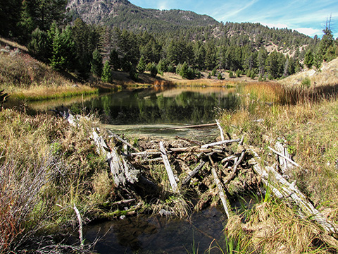
This project investigated how climate change over the last 21,000 years, which was characterized by significant warming, influenced vegetation in the Southern and Middle Rockies. We found that rapid vegetation change was initiated across these landscapes once a 2 ℃ temperature increase was realized and again recently with reduced rainfall. Southwesterly slopes in the Southern Rockies were prone to rapid change, otherwise landscape features didn’t have a strong effect. We also examined vegetation transformations (e.g., sagebrush steppe switches to a lodgepole pine forest) and identified between one and four vegetation transformations at each site, for a total of 60 transformations, over half of which occurred rapidly. This work provides a novel understanding of vegetation change that integrates climate change and landscape context, and helps to anticipate when (once our climate warms by 2 ℃ (before 2050)) and where (southwesterly slopes in the Southern Rockies) rapid vegetation change and transformation will be likely. The following details describe the scripts for the paleoecological portion of the NC CASC project 'Risk of ecological transformation across the US West and Pinyon woodlands' which are located in GitLab.
Trees are bioindicators of global climate change and regional urbanization, but available monitoring tools are ineffective for fine-scale observation of many species. Using six accelerometers mounted on two urban ash trees (Fraxinus americana), we looked at high-frequency tree vibrations, or change in periodicity of tree sway as a proxy for mass changes, to infer seasonal patterns of flowering and foliage (phenophases). We compared accelerometer-estimated phenophases to those derived from digital repeat photography using Green Chromatic Coordinates (GCC) and visual observation of phenophases defined by the USA National Phenology Network (NPN). We also drew comparisons between two commercial accelerometers and assessed how placement height influenced the ability to extract seasonal transition dates. Most notably, tree sway data showed a greenness signal in an urban environment and produced a clear flowering time-series and peak flowering signal (PF), marking the first observations of a flower phenophase using accelerometer data. Estimated start of spring (SOS) from accelerometers and time-lapse GCC were more similar than start of autumn (SOA); accelerometers lagged behind the time-lapse camera dates by three and four days for SOS and 13 and 14 days for SOA for each tree. Estimates for SOS and SOA from accelerometers and time-lapse cameras aligned closely with different NPN phenophases. The two commercial accelerometers produced similar season onset: a difference of 2.4 to 3.8 days for SOS, 2.1 days for SOA, and 0.5 to 2.0 days for PF. Accelerometers placed at the main crown branch point versus higher in the canopy showed a difference of 0.2 to 4.9 days for SOS and -1.5 to 1.7 days for PF. Our results suggest accelerometers present a novel opportunity to objectively monitor reproductive tree biology and fill gaps in phenology observations. Furthermore, widely available accelerometers show promise for scaling up from individual trees to the landscape level to aid forest management and assessing climate change impacts to tree phenology.
Recent fires have fueled concerns that regional and global warming trends are leading to more extreme burning. We found compelling evidence that average fire events in regions of the United States are up to four times the size, triple the frequency, and more widespread in the 2000s than in the previous two decades. Moreover, the most extreme fires are also larger, more common, and more likely to co-occur with other extreme fires. This documented shift in burning patterns across most of the country aligns with the palpable change in fire dynamics noted by the media, public, and fire-fighting officials.
Ungulate populations across the West have adapted to specific patterns in forage quantity, quality, and timing that ultimately influence the number of animals. We assessed potential for climate change to affect forage quality and availability for ungulates in the West. First, we evaluated multiple satellite remote sensing datasets and found that in some parts of the western U.S., growing season dates have shifted by over 30 days. We found agreement in the direction of recent trends in growing season dates across ~60% of the West. Substantial shifts in vegetation timing can have outsized effects on the wildlife that depend on matching migration timing to spring green up. For example, migrating mule deer follow the pattern of vegetation as it greens up in the spring when it is most nutritious. We assessed how green-up will change and how changes may affect mule deer migration in Wyoming. We projected that green-up of vegetation will generally occur earlier, particularly in drier years. We found future green-up along deer migration paths will be shuffled and of shorter duration, potentially decreasing the availability of high quality forage. This reduction in the benefit of migration could reduce the number of migrating deer. If local forage resources limit resident population size, mule deer abundance could decline. We provide baseline information on recent changes in the timing of forage, a framework to assess climate effects on forage, information on the quality of remote sensing data sources used for this research, improved understanding of the connections between climate and vegetation timing, and maps of projected future green-up. These products will be useful for biologists as they plan habitat treatments, consider effects of energy developments, and manage big game populations.
States in the North Central (NC) region have already been invaded by grass speciescapable of altering fire regimes and creating self-perpetuating 'grass-fire cycles'. Under climatechange, these grasses may interact with drought and fire to burn more and exclude native species. Managers can plan for these interactions and create collaborative communities to address thesecomplex challenges.
The National Park Service (NPS) is responsible for managing livestock grazing in nearly 100 parks, and several park grazing management planning efforts are currently underway. However, there is a recognized need to update grazing management practices to be responsive and adaptive to future climate change. As a step toward developing a process to address this need, this project worked with Dinosaur National Monument to consider climate change in its grazing management planning process. In this project, we convened researchers, managers, subject-matter experts, and climate change adaptation specialists through a participatory climate change scenario planning workshop to develop and apply a small set of challenging, plausible, relevant, and divergent scenarios that qualitatively assessed how grazing resources and management may be affected under climate change.
When
In April 2022, the NC CASC celebrated Earth Week by hosting Climate Solutions Days, an à la carte offering of presentations, workshops and trainings scheduled throughout the week where scientists and practitioners shared insights on climate change impacts from findings in the North Central region. Themes woven into panel presentations, working groups, listening sessions, trainings and tools included:
NC CASC March/April 2022 Newsletter Now Available Online
Contact Us
Want to see more? Do you have feedback? Was this site helpful? Send us an email!